
Gwo-shyh Song, Associate Professor at the National Taiwan University and Global Aqua Survey Ltd, walks us through his high-resolution seabed geophysical survey research around offshore areas in Taiwan
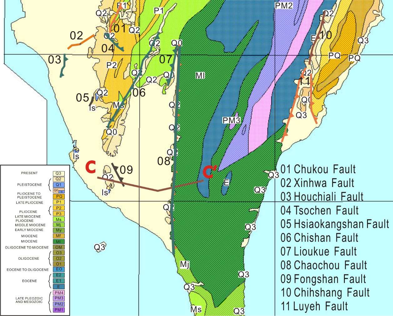
Taiwan Island is located on the complex convergent boundary of the Eurasian Plate and the Philippine Sea Plate in the circum-Pacific seismic belt, with the Ryukyu Trench subduction in the north-east and Manila Trench in the southwest. The Eurasian Plate goes east along the Manila Trench in southern Taiwan and slides under the Philippine Sea Plate. Plate collision stress gave rise to several north-south reverse faults in western Taiwan, which strengthens to the southwestern areas including the Chukou (No.01), Xinhwa (No.02), Houchiali (No.03), Chishan (No.06), and Chaochou faults (No.08) from northwest to southeast (Figure 1). The activities of these faults indicate that the tectogenesis of the Pingtung plain area tucked between the Chishan and Chaochou faults is rather active.
In recent years, geodetic survey results have shown that this area has a tendency of moving towards the southwest direction compared with its two faults. Scholars have clarified that such a phenomenon as the south-west block slip movement is caused by Taiwan orogeny.
Dr Gwo-shyh Song had conducted several projects for the Taiwan Earthquake Research Center, funded by the Ministry of Science and Technology, to make a high-resolution seabed geophysical survey around offshore areas in Taiwan. Its main purpose is to outline the seaward extension of the active faults that have been shown on land and then to capture its tectonic behaviour and its occupation in the offshore territory. The survey tools use a multibeam echo sounder, side-scan sonar, and a 3.5 kHz sub-bottom profiler. Below are some examples of providing seafloor sonar images to support the fact that Taiwan tectonic blocks have been continuously deformed under orogenic processes.
Offshore the Xinhwa Fault
In the Tainan offshore, the results of a pair of valley tectonic activity near the shore show that the main fault will extend outward along the axis of the North Valley (red dot line shown on Figure 2), and outwards the North Valley it shows a shallow dipping normal fault group mainly in the north seabed, and a pair of fault lines extend in the direction towards a pull-apart basin.
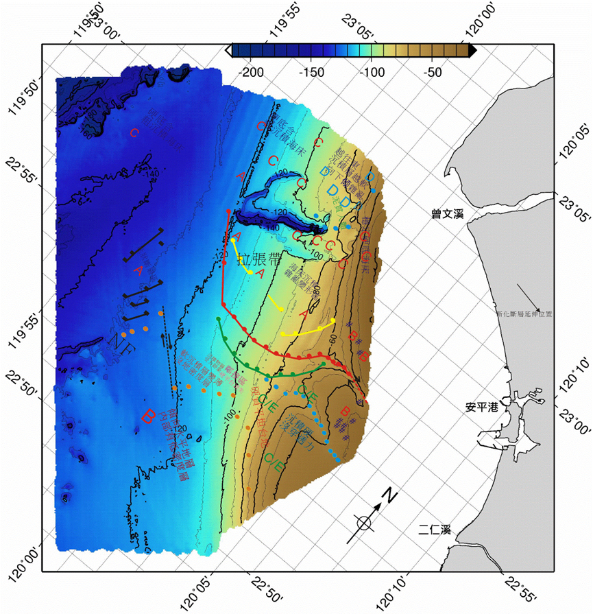
In the southerly region south of the valley, seabed sediments are squeezed and pressurised. Thus, because of the low-angle normal fault line that turns northwards towards the outer sea, and because the area is bounded by the valley, the north and south sides show the relative effect of so-called stretching and compression, indicating that there is a right-lateral strike-slip active fault in the offshore of Tainan and that the activity gradually terminates along the valley. The end of the fault produced at the end of the seabed crack form is in line with the performance behaviour of the so-called fault tip.
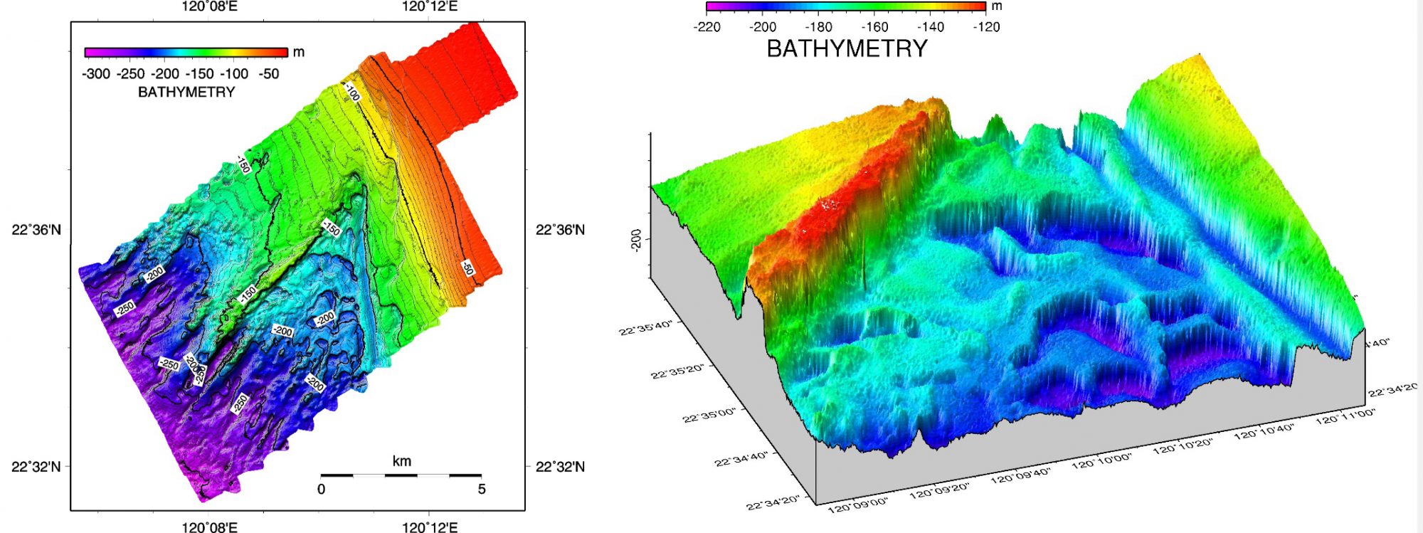
Offshore the Chishan Fault
Bathymetrical data has indicated that the fracture of the seabed was caused by left-lateral fault motion, and this motion brought subsidence of the seabed to its southern region (Figure 3). Subsidence comes from the motions of a series of normal faults with their direction conjugated with the direction of left-lateral strike-slip fault (Figure 4). Due to the consequence of Taiwan orogeny, it has brought compressive forces to the north part of the orogen, such that a force rebound occurs to its south. Under further compression, a fracture plan is created in-between, the southern block can be moved in a reversed direction to the northern block across this plane. This generates motions exerted along a left-lateral fault plane. When left-lateral motion occurs, the deep-seated crust is pulled by the eastward rebound force, such that the surface can be peeled off or collapsed under the motion of shallow-seated normal faulting.
*Please note: this is a commercial profile


