In a recent interview, our editors delved into the world of soil health monitoring and the transformative role played by artificial intelligence (AI), big data, and machine learning, with Mogens H. Greve, Professor and Head of the Soil Section at the Institute of Agroecology, Aarhus University
Professor Mogens H. Greve, provided valuable insights into the evolving landscape of soil science and its intersection with cutting-edge technologies in this exclusive interview with Open Access Government.
The integration of soil mapping and AI Greve, an experienced soil mapping expert, has reshaped the conventional viewpoint by underscoring the pivotal role of soil mapping within the realm of AI for soil health.
His extensive career and contributions to the broader field have made him a key proponent of integrating soil mapping with AI techniques. This fusion of soil mapping and AI has instigated a profound transformation in soil monitoring practices over the past two decades.
The advent of machine learning, a subset of AI, has brought about a paradigm shift in this domain. Greve explained how the departure from manual approaches to embracing statistical and machine learning methodologies has substantially enhanced the efficiency and precision of soil mapping. This evolutionary process, spanning the last 15 to 20 years, relies heavily on vast datasets derived from point data collected through initiatives like the LUCAS soil sampling campaigns.
The process: From point data to predictive soil maps
The process involves moving from point data acquired through extensive soil sampling efforts to creating comprehensive predictive soil maps. These maps cover vast geographical extents, such as the pan-European region. Greve revealed that this transformation is fundamental to understanding the variability of soil properties on both local and continental scales.
The combination of target variable points and a myriad of environmental data, including climate and terrain variables, fuels the machine-learning models. With its Sentinel data, the Copernicus program has become an invaluable resource, enhancing the precision and scope of soil mapping activities.
The end result is a predictive soil map that provides a comprehensive view of soil characteristics across extensive regions. Importantly, this approach allows for calculating uncertainty maps, offering insights into the reliability of the generated soil maps.
AI4SoilHealth Project: A Pan-European Data Cube
While speaking to Open Access Government, Greve revealed more about the AI4SoilHealth project, a ground-breaking initiative aimed at constructing a pan-European data cube. This data cube encompasses crucial information required for high- quality soil assessment maps, covering soil health indicators e.g carbon, bulk density, and clay content. The project’s scope extends beyond data creation, actively involving soil community stakeholders and policymakers in Europe.
One noteworthy aspect of the AI4SoilHealth project is its focus on developing new soil health indicators. Greve emphasised the importance of establishing critical levels for indicators like carbon in different regions, ensuring a nuanced understanding of soil health across diverse regions and landscapes.
Soil monitoring and resilience law proposal
The interview touched upon the recent Soil Monitoring and Resilience law proposal by the European Commission. Greve expressed enthusiasm for this legislative initiative, characterising it as a pivotal step towards protecting soil health, a common good that, until now, lacked comprehensive protection.
With soil being the foundation of 95% of global food production, the proposed directive represents a significant stride in acknowledging the critical role of soil in sustaining life. Greve noted that the proposal aligns seamlessly with the objectives of ongoing soil mission projects funded by the European Commission, creating a harmonious synergy.
The crucial role of data harmonisation
As the discussion unfolded, Greve delved into the challenges and opportunities associated with implementing AI and big data solutions for soil health monitoring. A key challenge highlighted was the need for national monitoring activities to be comparable. Ensuring uniformity in sampling and analytical methods across different memberstates is crucial for the success of pan-European mapping efforts. If adopted, the impending Soil Monitoring and Resilience law promises to generate a substantially larger pan-European dataset by 2029, marking a milestone in soil data harmonisation.
Fostering Sustainable Agriculture and Environmental Conservation
The conversation pivoted to the broader implications of advancements in AI and data-driven soil health monitoring. Greve emphasised the concept of soil ecosystem services, underscoring the multifaceted roles soil plays in agriculture, climate regulation, and pollution filtering.
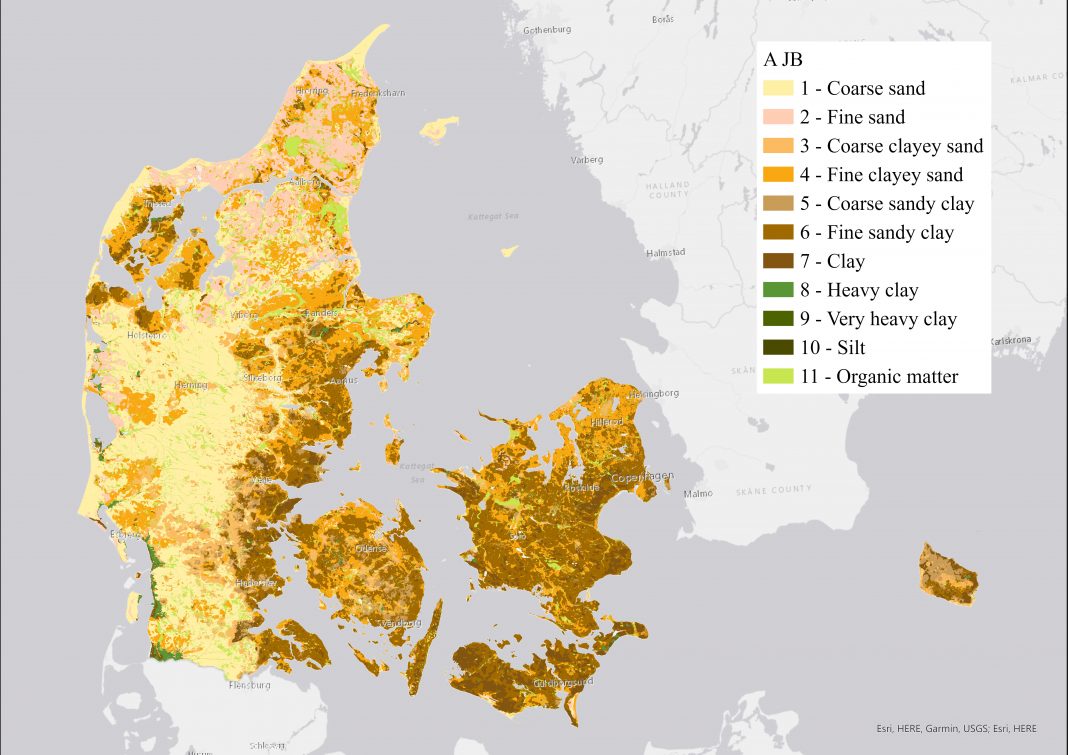
The ability to generate pan-European data cubes facilitates the monitoring of soil’s ecosystem capabilities. Greve stressed the significance of moving beyond a focus solely on short-term productivity. The broader European community is increasingly recognising Greve cited successful examples of AI- driven soil data informing policy decisions. For instance, soil maps produced in Denmark (see map above) influence regulations on nitrogen fertiliser usage, illustrating the tangible impact of high-quality soil data on political and agricultural decisions.
The role of AI in agroecology
As the interview neared its conclusion, the spotlight turned to the integration of AI in agroecology. Greve, drawing on his role at the Institute of Agroecology, highlighted the significance of large-scale mapping informed not only by remote sensing but also by proximal soil sensors. The goal is to create high-resolution maps that can inform precision agriculture practices, including irrigation and erosion protection.
The use of drones in this context allows for efficient data collection, enabling farmers to make informed decisions on nutrient and water usage. The overarching aim is to enhance efficiency, increase crop yields, and maintain soil quality while reducing overall agricultural production costs.
Navigating a sustainable future
Professor Mogens H. Greve provided a fascinating glimpse into the evolving landscape of soil science and its intersection with AI and big data technologies. From the intricacies of soil mapping to the transformative potential of pan-European data cubes, Greve illuminated the path towards sustainable agriculture and environmental conservation.

This work is licensed under Creative Commons Attribution-NonCommercial-NoDerivatives 4.0 International.


