
Thousands in the Pacific Northwest face a heightened flood risk, not just from rising sea levels, but from the land itself potentially sinking. A new study details how a major earthquake could drastically expand vulnerable coastal areas
The Pacific Northwest faces a growing threat of increased flooding. New research has highlighted the potential for a major earthquake, combined with rising sea levels, to significantly expand coastal floodplains in northern California, Oregon, and Washington.This could impact thousands of residents and properties.
Earthquake-driven subsidence
The research, published in the Proceedings of the National Academy of Sciences, led by Tina Dura, assistant professor of geosciences at Virginia Tech, indicates that a large earthquake in the Cascadia subduction zone could cause coastal land to sink by as much as 6.5 feet. This subsidence would dramatically expand the 1% coastal floodplain, the area with a 1-in-100 chance of flooding annually, by 35 to 116 square miles.
Dura’s team generated numerous earthquake models to estimate the range of potential land sinking from a future Cascadia earthquake. They then used geospatial analysis to quantify the expansion of the floodplain at 24 estuaries and communities along the subduction zone. The models considered the impacts of an earthquake occurring today and in 2100, factoring in climate-driven sea-level rise.
Impacts and vulnerable areas
The research indicates that the most severe effects would be felt in densely populated areas of southern Washington, northern Oregon, and northern California. The study estimates that an earthquake today would place an additional 14,350 residents, 22,500 structures, and 777 miles of roadway within the post-earthquake floodplain, effectively doubling flood exposure. Critical infrastructure, including airports, schools, hospitals, and wastewater treatment plants, would also be at risk.
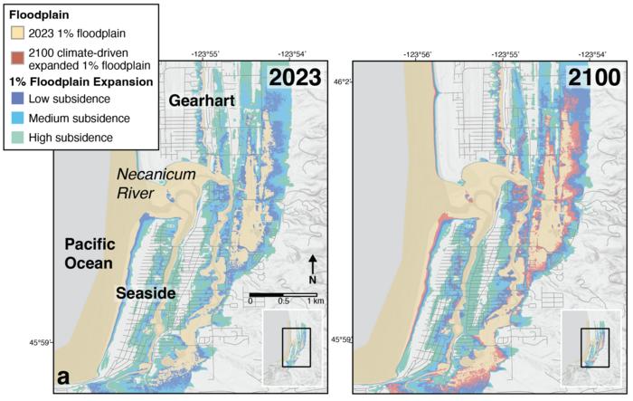
The role of sea-level rise and increased flood risk
The Intergovernmental Panel on Climate Change (IPCC) projects that sea levels along the Cascadia subduction zone could rise by up to 3 feet by 2100. This rise would amplify the effects of earthquake-driven subsidence, more than tripling the flood exposure of residents, structures, and roads.
Dura notes that the immediate effect of subsidence, especially combined with rising sea levels, would delay earthquake response and recovery efforts. Long-term, many coastal communities could become uninhabitable.
Examining the ecological consequences
The increased tidal inundation would cause significant economic losses in low-lying areas used for cattle grazing and farming due to soil salinization. Natural ecosystems, such as coastal estuaries, intertidal wetlands, and protective dunes and beaches, would also suffer erosion. The loss of intertidal wetlands, which act as natural carbon sinks, would further reduce their ability to sequester carbon, impacting ecosystem services like water filtration and habitat for fisheries.
Global implications
The Cascadia subduction zone is part of the “Ring of Fire,” a region known for its high frequency of strong earthquakes and volcanic eruptions. Dura’s research underscores the global relevance of these findings, as subduction zones are located off the coasts of Alaska, Russia, Japan, Indonesia, New Zealand, and South America.
Understanding the impacts of earthquakes and subsidence in Cascadia can inform hazard assessments and mitigation strategies for other tectonically active regions worldwide.

: What every cat owner needs to know")


