To tackle legacy pollution and non-point source pollution, we must identify the sources, sinks and hot spots – but is it already too late?
Changes to the natural landscape are pervasive. The construction of dams, alterations to river water courses, flood controls, farming, urbanization and deforestation all contribute to the current condition of our water resources. Compounding this are alterations in precipitation driven by changes in climate. We now see greater intensification in precipitation and widespread variability in distribution. This creates what many authors describe as a “wicked” problem. Our freshwater streams and rivers flow through an altered landscape driven by an intensifying water cycle. Improvement in water quality is a very difficult task.
We must understand and identify “hot spots”
To tackle such problems, an understanding of sources and sinks along with areas of intensification or “hot spots” must be clear. Spreading management expenses and fixes throughout a region may not produce observable or necessary improvements in water quality other than money spent. Reductions in pollutant runoff or improvements in stormwater treatment applied to farms or urban landscapes may be offset by “legacy” pollutants stored in the system from previous disturbances. Legacy pollution exists in streambank soils and throughout the stream bed creating the primary underlying material that streams flow through and move during storm events. Intense storms work to activate these pollutants by resuspending sediment and pulling deposited material from stream banks back into the water. With each storm, sediment moves down the channel while upstream erosion resupplies more and more easily movable soil. Legacy sediment hotspots are created becoming the primary problem in stream channels – causing most of the problems. This disconnect between watershed management practices and observable stream water quality improvement will take decades to resolve and only when the systems flush existing pollutants through.
Rivers already burdened by legacy sediment
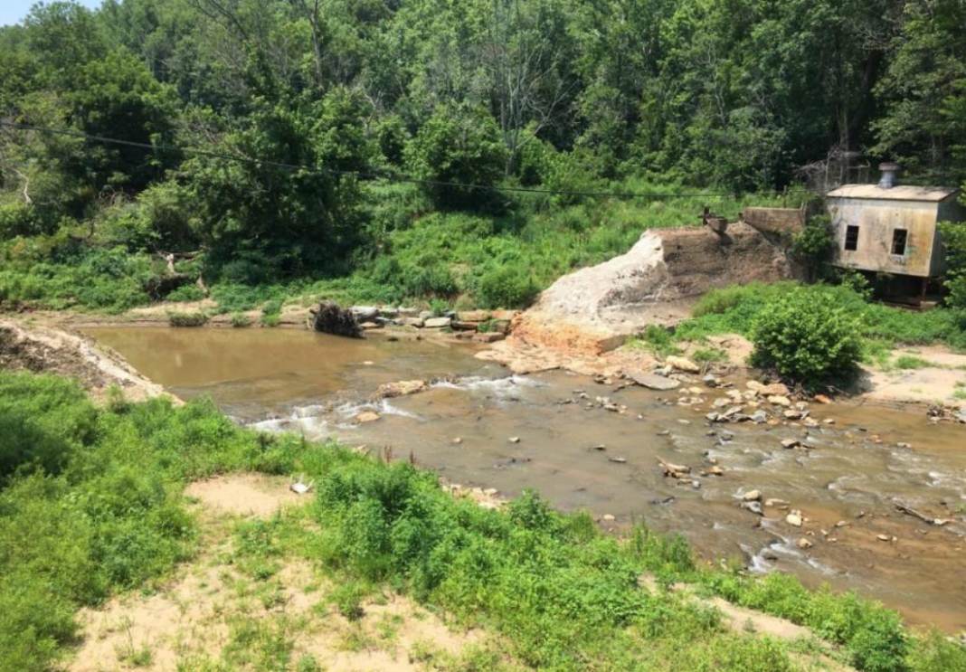
Further, our rivers have been historically altered by dams (Figure 1). Each of these structures is characterized by a particular volume of water impounded and a watershed drainage network above. The current trend of dam removal while admirable and with certain positive attributes is also unleashing even more legacy sediments into the system. This sediment must be processed, distributed and eventually washed through into our bays and oceans. Hence, adding additional sediment stored behind dams to a river system already burdened by legacy sediment and land use changes severely compounds a difficult problem.
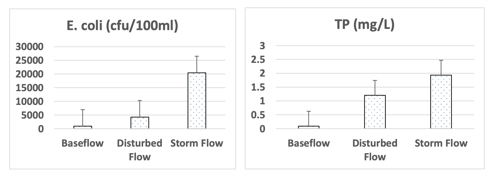
To generate some insights on this problem, stream flow of a river recently impacted by a dam removal was studied under 3 types of flow conditions; baseline, disturbed bottom and stormwater. Under baseline flow, water samples were analyzed directly while stormwater was measured during a bankfull storm event. The disturbed bottom measures occurred during baseline flow with multiple individuals disturbing the stream bottom and banks forcing sediment into the stream that mimicked turbidity during a stormwater event.
It was clear from this experimentation that the disturbance of sediment on the stream bottom and banks was enough to produce significantly higher concentrations of both bacteria and nutrients (Figure 2). Clearly, additional levels of pollution were evident during storm flow yet it was not possible to determine if any of the additional pollutant loading occurred outside the stream channel from land runoff or directly from streambank erosion. Regardless of the source, this experimentation demonstrated the potential for the sediments in the streambed to be significant contributors to pollution loading and the importance of legacy sediments.

Legacy pollution must be considered in management of water resources
This leads to the idea that time lags and legacy sediments must be considered in the management of our water resources. A body of literature now exists (reviewed by Vero et al. 2017) suggesting that the missing of water quality targets in dead zones of major managed aquatic ecosystems (such as the Baltic Sea or Gulf of Mexico) may be the result of time lags and legacy pollutants flushing from the system.
This forces very difficult policy positions as extensive and expensive measures implemented throughout a watershed may have minimal or non-existent results. But this phenomenon may well explain why a greater frequency of storm events accompanies a worsening of water quality. Thus, policy makers need to characterize storms as a cleansing or flushing event rather than a pollution event. Further, the temptation to correlate lower flow years with good water quality needs to be avoided. This may simply represent a greater storage of legacy pollution thus causing more difficult explanation scenarios after heavy rains.
Is it too late for our streams and rivers?
Thus, the damage to our streams and rivers may have already occurred. It is incumbent on us to manage these systems allowing them to “recover” and most importantly, equilibrate with the watershed they flow through. The constant changing of hydrology by development and land cover changes may be the greatest problem and challenge to improvement of water quality. Globally, streams and rivers need time to equilibrate, flush and mend before we will see significant outcomes from our land management and treatment technologies.
References
- Fleming, P., Walter, R., and D.J. Merritts. 2019. Legacy sediment and erosion hot spots: A cost effective approach for targeting water quality improvements. Journal of Soil and Water Conservation 74:67A-73A.
- Shortle, J.S., and R.D. Horan, 2017. Nutrient pollution: A wicked challenge for economic instruments. Water Economics and Policy 3:1-39.
- Vero, S. E., Basu, N. B., Van Meter, K., Richards, K. G., Mellander, P. E., Healy, M. G., & Fenton, O. 2018. The environmental status and implications of the nitrate time lag in Europe and North America. Hydrogeology Journal, 26:7-22.

This work is licensed under Creative Commons Attribution-NonCommercial-NoDerivatives 4.0 International.


